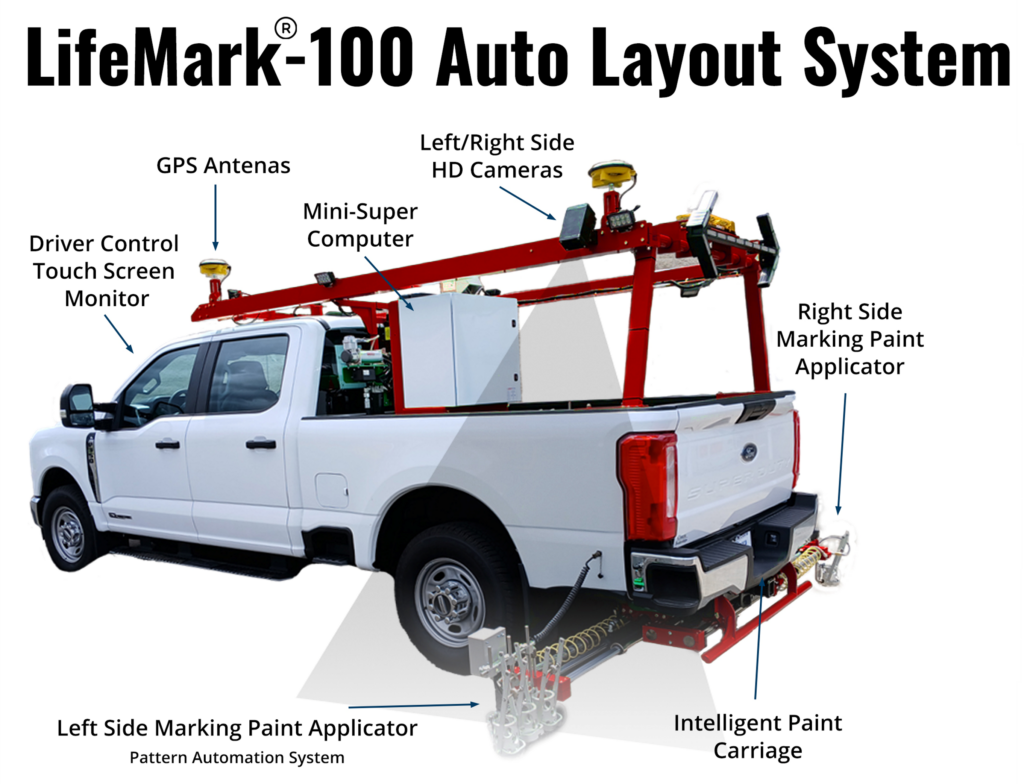
Since GPS was made available for public use in 1983, this powerful technology has worked its way into our everyday lives—from guiding us to grandma’s house to locating a 6-inch-wide pavement marking with pinpoint precision.
How It Works
At its core, GPS (Global Positioning System) uses a network of satellites orbiting the Earth. These satellites continuously transmit signals. A GPS receiver calculates its position by measuring the time it takes for these signals to reach it from multiple satellites. With at least four satellites in view, it can triangulate your location on Earth.
But there’s a catch…
Why Standard GPS Isn’t Enough
Publicly accessible GPS is typically accurate to about one meter (around three feet). That’s fine when you’re navigating city streets—but it’s far from acceptable when you’re trying to paint lines on a highway that must be accurate within a few centimeters. Imagine road stripes being off by several feet—not safe, and certainly not efficient.
Enter RTK: Precision through Correction
To achieve the precision needed for pavement marking, GPS-guided systems rely on RTK (Real-Time Kinematic) correction services.
In simple terms: RTK uses a fixed base station that knows its exact position. It compares that known position to the GPS signals it receives and sends corrections to the pavement marking machine in real time. This process adjusts for satellite drift, atmospheric delays, and the constant rotation of the Earth—shrinking the margin of error from feet to centimeters.
More Than Just RTK: The Role of INS
RTK gets us close, but when the system is mounted to a moving vehicle, additional challenges arise. Factors like vehicle speed, turning, tilt (pitch and roll), and rotation (yaw) can throw off positioning.
Accuracy is never more critical than during the layout process, when small tick marks are placed on the pavement to guide the operator in exactly where the final lines should go. Even minor errors in these reference points can lead to off-spec markings.
That’s why the LifeMark-100 Auto Layout System also includes an Inertial Navigation System (INS).
Put simply: An INS is a suite of internal sensors—like gyroscopes and accelerometers—that track the vehicle’s movements in real time. When combined with GPS and RTK correction data, the INS helps maintain pinpoint accuracy even when the vehicle is turning or driving on uneven surfaces.
This powerful combination allows the LifeMark-100 to deliver centimeter-level accuracy—even at highway speeds.
More Than Just GPS
Accurate positioning is only one part of the puzzle. Today’s most advanced pavement marking systems also use robotics, computer vision, and artificial intelligence to guide layout and application with minimal human intervention. This is where precision meets automation.
Why It Matters
The goal of GPS-guided pavement marking systems is simple: to make road work safer, more accurate, and more efficient. By reducing the need for manual layout, these systems protect workers, improve quality, and reduce project time and cost.
For more insights into the difference between mini-robotic layout tools and vehicle-mounted systems, see our article: “Battle of the Bots.”
Paving the Way Forward
Automation is not just a convenience—it’s a transformation. GPS-guided pavement marking is helping usher in a new era of safer roads, smarter work zones, and a more efficient future for the road construction industry.
Download Article
